)
) 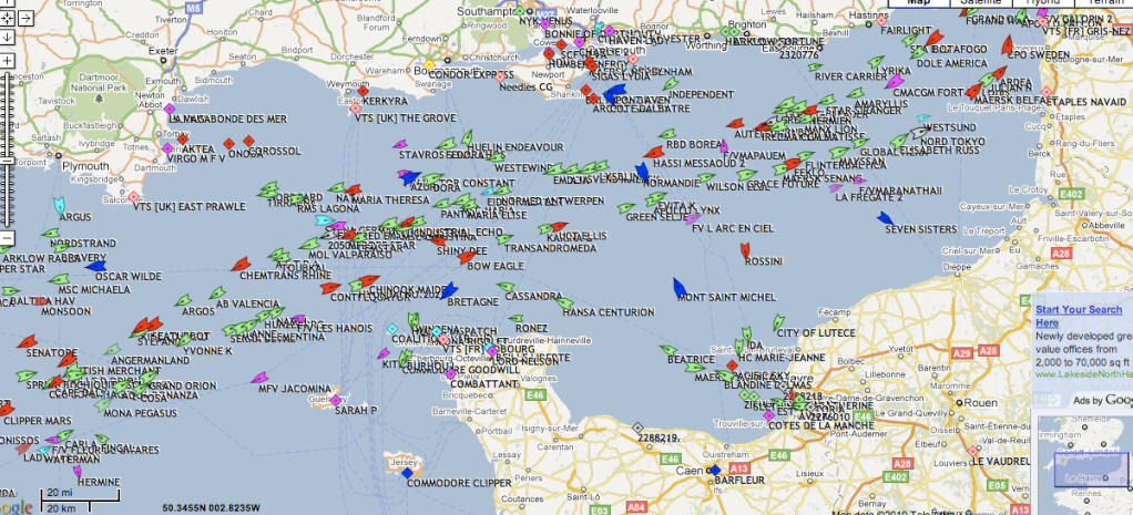
I use http://www.shipais.com/gmap2.php to see what boats are currently around. I use it on my phone when Im walking on the coast to find out where boats are going and what they are
Mini Mad


Posted 28 April 2010 - 12:16 AM
)
Original Spamster

Posted 28 April 2010 - 06:30 AM
OK cheers, so how does the cross-Channel stuff manage to thread through that lot?Does that mean like on a dual carriageway?that just shows the ships are in the traffic separation lanes
yes works in much the same way
Original Spamster
Posted 28 April 2010 - 06:33 AM
So these are the main shipping lanes then? And, keeping to the right, the thicker line is heading southwest, and they're all moving? In which case that's NOT the place to drop anchorMost would appear to be on the way out. Thought they clockwork moused in the Bay of Biscay waiting for the oil price.
TMF Legend
Posted 28 April 2010 - 09:06 AM
I use this site which also locates tall ships, the sailing clippers etc, which go on very romantic-sounding cruiseshow did you find out what ships are in the channel?
That is really cool, thanks. I expect Mrs T will be tap-tapping her i-phone as we stroll along the cliffs. Not too close to the edge, dear ...I use http://www.shipais.com/gmap2.php to see what boats are currently around. I use it on my phone when Im walking on the coast to find out where boats are going and what they are

Edited by Teapot, 28 April 2010 - 09:10 AM.
Original Spamster
Posted 28 April 2010 - 11:07 AM
One Carb Or Two?

Posted 28 April 2010 - 01:07 PM
Up Into Fourth

Posted 28 April 2010 - 01:33 PM


0 members, 1 guests, 0 anonymous users